This is the story of my first commercial drone job in December 2016, after I had become an FAA-Certified Drone Pilot.
I’m sharing this with you to show you that getting that first client is well within your reach, and not as daunting as it may appear.
So what was this first gig?
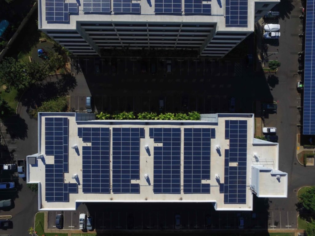
To take four photos: one each of four separate solar panel arrays (600+ panels in total). Two of the solar panel arrays were located on separate 7-story apartments, while the other two were located on newly constructed carports.
These photos were to be used to prove to the electric utility that the correct number of panels were installed. This was part of the commissioning process, and had an urgent deadline (ASAP), because any delay with the photos could delay the customer from receiving energy credits.
I got a call one morning from a friend of a friend - someone within my own personal network that worked as an Engineer for a solar company. I had been very vocal within my own network that I held my Remote Pilot Certificate with sUAS Rating, posting on Facebook, LinkedIn and letting everyone know in person.
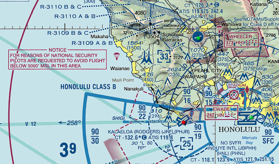
On this call, he asked if I could capture aerial photos of each of the solar arrays at a particular address. I also asked when he needed the photos delivered by (answer: the next day). With him on the phone, I looked up the address, and compared it to the sectional chart for that area to check the airspace.
The address was in uncontrolled Class G airspace, so we were in business!
He also asked how much it would cost. I blanked at first…no one had ever asked me that.
I figured it would take about 3 hours total with driving, setup, and the operation so I quoted him 3 hours at $40 hour for a total of $120 (plus our state excise tax).
He agreed, and the plan was for me to take the photos the next day at 11am.
That afternoon, I made sure my Phantom 3 Advanced had the most current firmware, memory card wiped clean, and charged all batteries.
The next morning, I gave myself plenty of time to get to the site early.
Once on site, I called the Engineer and he explained everything had been cleared with the property manager, and that I needed to just introduce myself to the on-site security guard.
Simple.
I walked the job site, looking for any hazards that didn’t show up on my research in Google Earth.
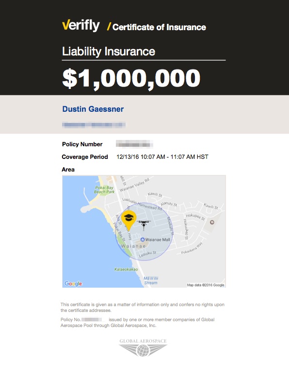
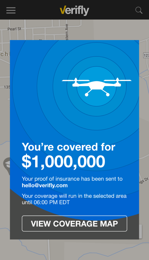
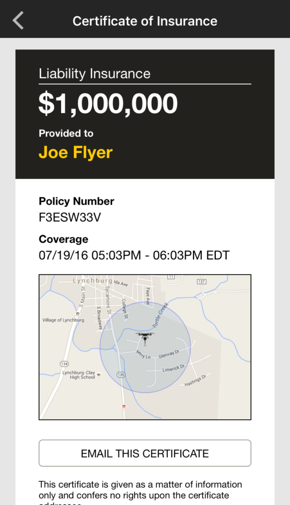
With no unidentified hazards, I purchased a Verifly $1.0 million insurance policy for 1 hour with a 1/4 mile radius for $15 and ran through my pre-flight checklist.
I flew my drone and captured the 4 images required, then I took several videos and additional photos to create a 3D model of the site.
Always overdeliver!
Upon landing the drone, I verified the capture of the required images. They looked great!
My job was completed on-site, so I gave the Engineer a call to let him know everything was wrapped up, and that I would send over the deliverables via Dropbox later that afternoon.
Overall, I was on site for 1 battery, or about 30 minutes including the site walk-through.
Once home, I sent over the images and processed the 3D Model in DroneDeploy.
I got the go ahead to sent the invoice over, then it was just time to wait for the check.
In total, it took less than 24 hours to receive my first job, plan it, fly it, then deliver.
$120 for roughly 3 hours of work was not too bad for my first job!
Biggest Lessons:
"Of course we can do the operation...we just can't do it for 3 months," I said to the client.
He looked at me bewildered.
I continued, "This is Class D airspace. To legally perform this operation, I need to apply for an airspace authorization. It can take up to 90 days for the FAA to approve requests like this."
I'll get started on it right away."
This was a real conversation I had with a client several months ago to perform aerial photography over a sandbar on the island of Oahu.
This article will go over the step-by-step process I went thru to get my Class D Airspace Authorization for operations on May 1, 2017.
An airspace authorization is required for permission to fly within controlled airspace (Class B, Class C, Class D, and surface level Class E). Airspace authorization is only available to Part 107 certified pilots.
If you're not certified yet, check out the Remote Pilot Test Bank for a full study plan and 300+ practice questions.
In the past (before Part 107 Rules were implemented), an operator just needed to contact the air traffic controller prior to flights.
However with the implementation of Part 107, all requests for permission in controlled airspace is required to be completed thru the FAA's Online Portal.
The FAA asks for 90 days from application date to proposed operation date, to review the request and apply any conditions or criteria.
When applying for operation in controlled airspace (107.41 Operation in certain airspace), you'll notice there are two types:
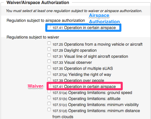
The types of waivers and airspace authorizations that a Remote Pilot can apply for.
Waivers are requests to fly outside the standard operating rules that Part 107 dictates. Typically this is for things like operations at night, operations over people, and beyond visual line of site (BVLOS).
A waiver for "107.41 Operation in certain airspace" is a request to be exempted from needing permission to fly in controlled airspace. These requests are getting approved very rarely.
In this case, the desired operation has a defined date (May 1, 2017) within Class D airspace, so I applied for an Airspace Authorization.
This is the most important step.
Ask yourself these questions:
Be conservative with your estimates, but identify the minimum values needed for this operation.
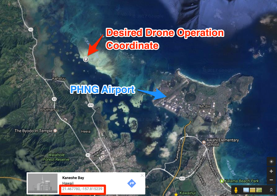
To find the coordinates of this operation, pull up Google Maps Satellite view.
Now convert these decimal coordinates to degrees minutes and seconds. The easiest way to do that is with this website.
21.467780 degrees latitude = 21° 28' 4.008" N latitude
-157.815239 degrees longitude = 157° 48' 54.8598" W longitude
Now, using these decimal coordinates, scroll around in SkyVector moving the center of the map "+" until you align the GPS coordinates from your desired operation (N21° 28' 4" W157° 48' 54")
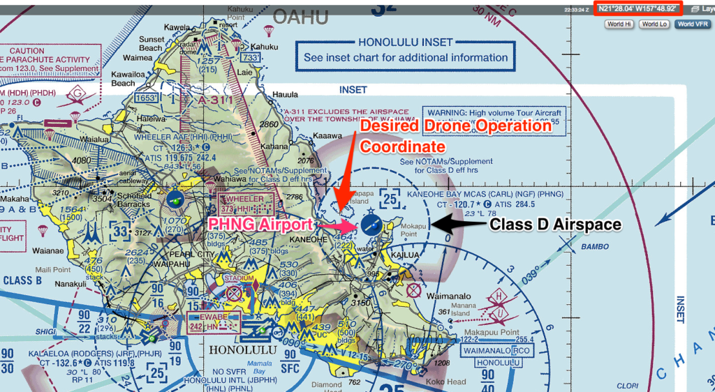
We see here that it is within Class D airspace.
Please note: By checking the Chart Supplement, we can find the effective hours for this Class D airspace.
In this case, on the desired operational day (Monday May 1, 2017), the airspace is Class D.
There are detailed instructions from the FAA on how to fill out a waiver/airspace authorization request.
To fill out your airspace authorization request, start at the online form on the FAA website.
Below is a screenshot of my exact request for Class D airspace:
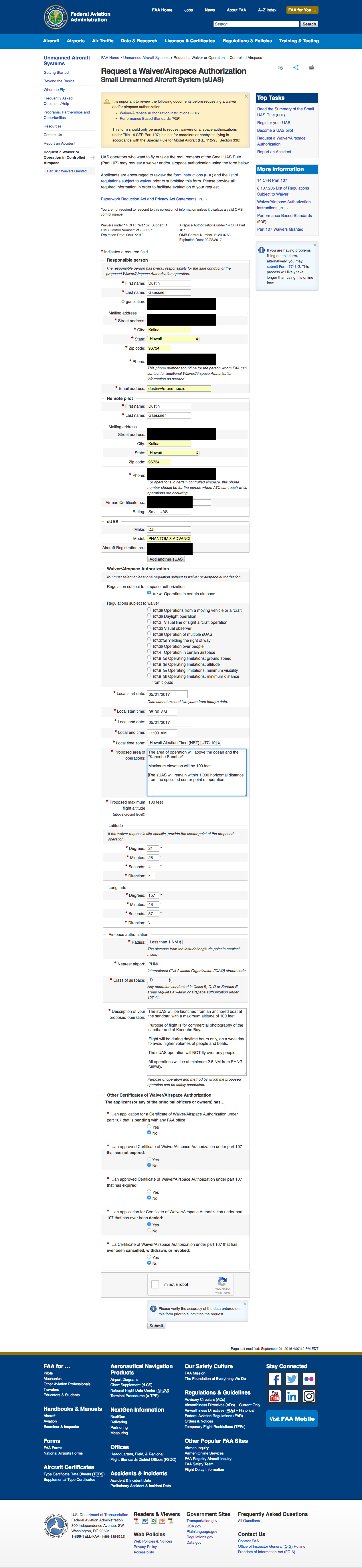
Completed FAA Class D Airspace Authorization request form.
Unfortunately, everything is reviewed manually by the FAA. Prior to April 2017, most operators submitting for waivers/airspace authorizations did not even receive confirmation that their request was submitted.
This has changed as of April 2017, where the FAA is including reference codes when each submittal occurs.
I submitted this Class D Airspace Authorization on January 28, 2017, and received notice on March 31, 2017.
Note how I requested a date of operation (May 1, 2017) over 90 days in advance. It is essential right now to give the proper notification to the FAA for them to approve it.
I received my authorization in a PDF via email on March 31, 2017.
It included details on about who to contact and how far in advance (24 hours, 30 minutes prior to flight, and immediately upon completion of sUAS flight operation).
There are also details for Emergency/Contingency Procedures, such as lost link or lost communication with the sUAS.
Take a look at my full airspace authorization approval PDF here.
I hope this walk-through was extremely helpful on how I successfully applied for and received airspace authorization for operation with a Class D airspace.
Please let me know if you have any questions or want to see other specific waiver/airspace authorization request walk-throughs.
Last week the FAA announced their Aerospace Forecasts for 2017-2037, which includes update forecasts for Unmanned Aircraft Systems.
You can read the full set of forecasts as a PDF here.
This blog post is a recap of the most important data for commercial drone operators. All data is current as of April 2017.
In June 2016, the FAA issued the small Unmanned Aerial System (sUAS) Rule (14 CFR Part 107) which took effect August 29, 2016.
This rule set provided a regulatory structure for the routine operation of small UAS for commercial purposes.
Based on trends and expert opinions, the FAA forecasts that the amount of Remote Pilots (those with the Remote Pilot Certificate with sUAS Rating) will likely grow to 420,000 by 2021.
This compares to 29,000 Remote Pilot Certificates that have been issued as of December 2016. This means there is huge projected growth in the volume of commercially certified pilots over the next 4 years.

The estimated growth of the number of Remote Pilots between 2016-2021.
As of February 2017, over 90% of individuals who took the remote pilot knowledge test had passed. This pass rate is only slightly higher than the private pilot test (~87%).
What does this mean for those thinking about becoming a Remote Pilot? Plan to take and pass the test ASAP!
Right now, there is barely any competition for commercial jobs. But within the next four years, the amount of certified operators will likely increase 10x fold!
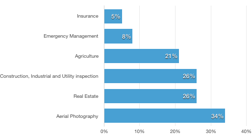
Major applications of small UAS commercial uses. Many of the sUAS have multiple uses, hence why the chart percentages exceed 100%.
We see with this data the vast majority of sUAS uses are for aerial photography and real estate.
This gives a fair assessment of where most drone operators have been focused on with their businesses, and where the opportunities for growth are.
There are many operating restrictions under Part 107, however, waivers can be applied for and requested.
Below is the breakdown for the top 5 waiver requests received by the FAA. The percentage of the chart exceeds 100% because of multiple requests at the same time.
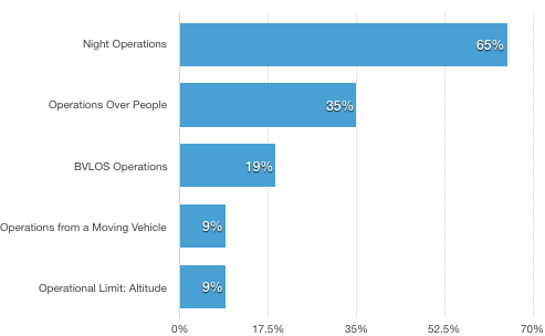
We see here that the highest requested waiver is for night operations. Looking on the waivers that have been issued, we see that no waivers for Operations Over People have been granted yet (as of April 2017).
Note: this list only includes waiver requests, and does not include requests for fly within controlled airspace (such as Class B, Class C, Class D, or Class E from the surface).
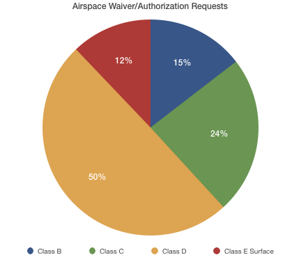
This data shows the breakdown of 6,835 airspace waiver/authorization requests. There is no data depicting the "issue rate" or "denial rate" of these requests.
The vast majority of requests (3,397 of 6,835) are for operations within Class D airspace (i.e. smaller airports with control towers).
The FAA is slowly approving waiver requests, so you can start planning to do operations that require a special authorization. Currently there is a 90 day window from request to authorization.
To apply for a waiver, you must do so on the FAA website: https://www.faa.gov/uas/request_waiver/
The process is fairly straightforward.
I recently received an authorization for operating in a Class D airspace, which I'll be going over a step-by-step in a future post.
What I learned was how specific you need to be with everything - from the time window of the operations, to the GPS coordinate, to the altitude.
I predict in the future the FAA will streamline the waiver request process to be near instant (not 3 months), but we'll see on that!
“Tomorrow? You want me to take photos of the solar array tomorrow?” I exclaimed. “Give me some time to do a little research and I’ll call you right back.”
I had just received my first call with a prospective client for a commercial drone job. What through me for a loop was that they needed the operation done ASAP, which in this case meant the next day.
I quickly checked the two most important aspects of the operation:
Within 5 minutes I called the client with a bid for the job. Those two questions were simple: it was Class G airspace so no authorization required, and the insurance would only cost $15 for one hour.
 Verifly is an on-demand service providing drone insurance that launched in August 2016, by two seasoned Entrepreneurs (CEO Jay Bregman and CTO Eugene Hertz).
I first learned about it in October of 2016, and downloaded the app with the idea that I could get insurance for any commercial job I may get in the future.
As a newly certified Remote Pilot (I passed the Remote Pilot Knowledge Test in September of 2016), I had slowly begun piecing together the parts of a new drone services business.
This included figuring out how to get drone insurance for commercial jobs. And this is where Verifly comes into the equation.
For startup drone operators, Verifly is a no-brainer. Hands down, it’s one of the most effective tools when starting your drone business.
There are some really big advantages to using Verifly vs traditional “annual insurance” policies.
Step 1: Determine the location for coverage
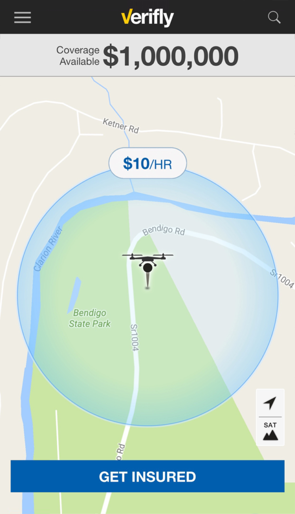
Step 2: Set coverage limits and duration
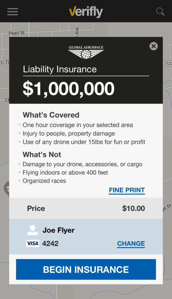
Step 3: Purchase Coverage
Step 4: Email Insurance Policy
Simple.
Jay Bregman says that Verifly can “save you money and hassle, no matter where you are in the spectrum” of drone operators.
Verifly is available in 48 states, and delivers on Jay’s message.
Whether you are a new commercial drone operator, or a recreational operator - Verifly is a great and easy way to get insurance coverage.
"Well, you should start with what you know." said Mike Winn, the CEO of Drone Deploy.
It hit me like a ton of bricks.
Of course. It's extremely simple and makes so much sense. A bit more on that later.
We had been standing in line to grab barbecue ribs at the 1st annual Drone Deploy Conference.
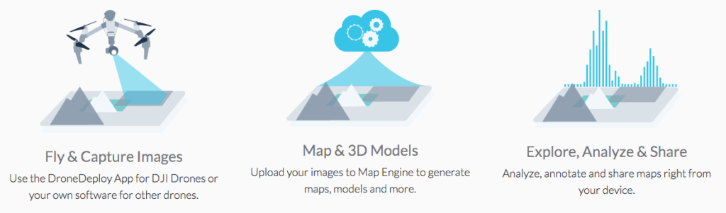
If you haven't heard about Drone Deploy, they're a software startup based out of San Francisco that has software to fly your drone, collect collect images, then generate orthomosaics, 3D models, and terrain models.
How the Drone Deploy works. (Source: www.dronedeploy.com)
November 3rd, 2016 was a user conference in their office, with speakers in a variety of industries (agriculture, surveying, construction, and service providers).
There were over 80 in attendance, not including the 20+ Drone Deploy employees helping and leading the event.
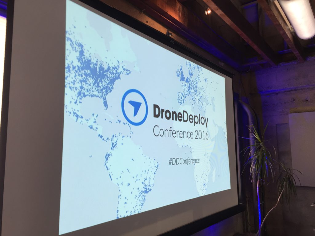
Conference in the Drone Deploy offices in downtown SF (November 2016).
If you're reading this, you're most likely a "service provider". That means you don't have any particular experience in one of the big industries that are currently using drones:
These industries have already been using drones to replace expensive, time-consuming, or unsafe manned operations.
In particular, the construction and agriculture industries are highlighted to be responsible for over $23 billion in market opportunities over the next 4 years (Goldman Sachs).
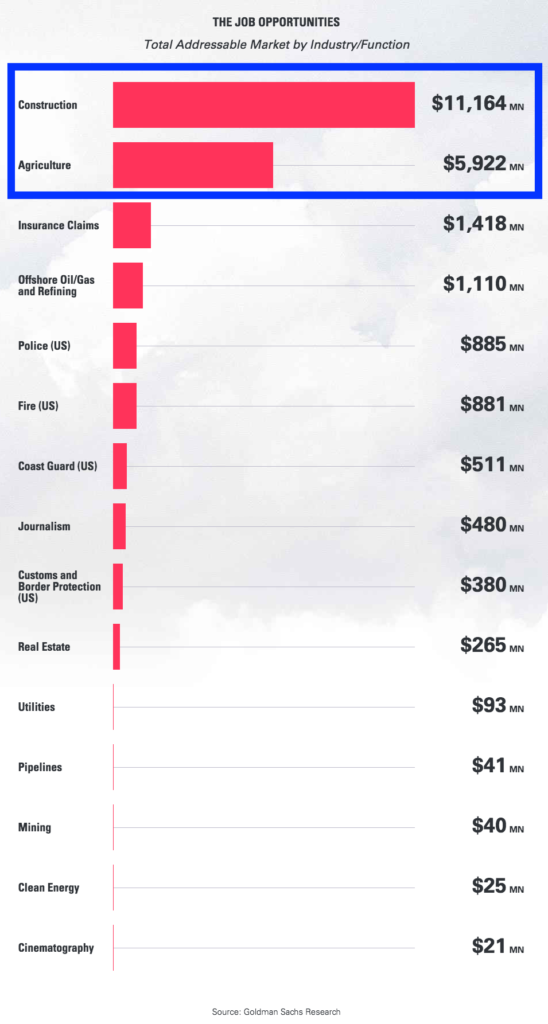
Construction and agriculture projected to be 74% of the $23+ billion commercial drone industry over the next 4 years. (Source: Goldman Sachs)
To put that in perspective, those two industries alone are predicted to account for nearly 74% of the commercial opportunities over that same time span.
That brings us to our first lesson.
As someone who is absolutely excited about the possibilities in the drone space, I needed to take a step back.
See, I have been thinking about how to use drones as a side-income for me. Something on the weekends, and maybe make an extra $500-$1,000 per month.
But I've been more focused on ME. And more importantly, how I can apply drones TO an industry.
Really though, it should be how drones can substitute tasks that industries already pay for.
Drones are just like any other new technology that disrupts industries. They are tools to reduce costs companies already have.
Software is the best example of this: everything from email (snail mail) to payroll (pad, paper, and countless hours) have been made more accessible and cheaper for companies.
Drones are just like that.
So instead of thinking up a "brand new way drones can be used", the approach should be how can drones be used to solve problems that already exist.
This type of thinking was was a huge shift for me during the conference.
Which leads us to the second lesson I learned.
We had a group of about 25 people in our "deep dive" discussing service providers.
Essentially it was a group who are enthusiastic about drones and the technology, but have no real idea where we can apply it and make money.
Understanding the problems of an industry can be very complex. Knowing what deliverables a drone can provide that saves a company a 5x return on cost is also difficult.
For an industry outsider.
That's where the advice from the Drone Deploy CEO comes in: start with what you know.
There's a reason most new drone operators decide to do real estate videos and photos: it's simple to understand.
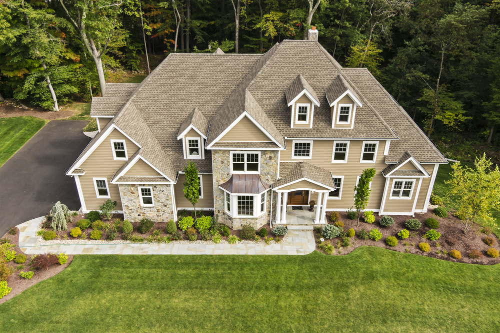
Drone real estate videography and photography are simple to understand. (Photo source: https://droneandquadcopter.com)
From the surface, the problem (showcasing the area and uniqueness of a property) and the deliverables (short video and photos) are as straight forward as they get. Additionally, who you need to talk to (real estate agents) makes sense.
That's not the case with these other big industries.
Do you know who would be responsible on a construction site for approving drone operations? What is a drone service deliverable for a construction site anyway?
That's why almost everyone flocks to real estate. Understanding.
The advice to start with what you know makes a lot of sense for me: I was a project engineer designing photovoltaic systems for residential properties in Hawaii for over 1.5 years.
I have a good idea of how drones can be applied (surveying, thermal inspections), but more importantly I have an understanding of the industry. And connections to talk with companies to learn more about the problems they face.

Thermal image of a ground-mounted solar farm (source http://adtsgroup.com/).
Think about your background. Think about your network. What knowledge do you already possess? Who do you know that you can ask about their industry?
So what should you do next?
In conclusion, we are at the forefront of the coming tidal wave of drone technology, and it's important to find your niche.
Countless other people have the same question you have ("what industries should I choose to offer drone services").
And we're all trying to figure it out!
Hey there...and welcome to the DroneTribe.
We're just getting started with everything that's being rolled out - blog posts, guides, videos, and more.
There's lots of good on the horizon 🙂
In the meantime, we suggest you follow us on Facebook (this is the best way to keep in the loop of our new articles, guides, and products).
See you soon,
Dustin