There are two primary types of weather reports a remote pilot will use during sUAS operations: METAR and TAF.
METAR = Meteorological Aerodrome Report (current time)
TAF = Terminal Aerodrome Forecast (future, between 24 - 30 hours ahead)
These aviation weather reports are designed to give accurate depictions of current weather conditions. Each report provides current information that is updated at different times.
To view a weather report, go to http://www.aviationweather.gov or https://www.1800wxbrief.com and enter the airport’s 4 letter identifier (such as KJFK or KLAX).
For the Remote Pilot Knowledge Test, you will need to understand how to read and decipher the information from this format (METAR example):
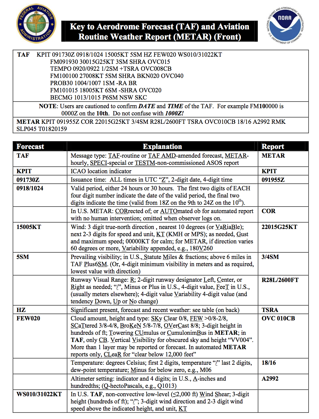
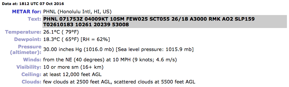
METAR PHNL 071753Z 04009KT 10SM FEW025 SCT055 26/18 A3000 RMK AO2 SLP159 T02610183 10261 20239 53008
However, when using these reports and forecasts in the “real world”, there will be an option to present this information in a decoded format:
Automated weather sources, such as the Automated Weather Observing Systems (AWOS), Automated Surface Observing Systems (ASOS), as well as other automated facilities, also play a major role in the gathering of surface observations.
A METAR is an observation of current surface weather reported in a standard international format. METARs are issued on a regularly scheduled basis unless significant weather changes have occurred.
METARs typically come from airports or permanent weather observation stations. Reports are generated once an hour or half-hour, but if conditions change significantly (such as rapidly changing weather conditions, aircraft mishaps, or other critical information), a report known as a special (SPECI) may be issued.
Here are the primary sections on how to read the METAR report:
1. Type of report—there are two types of METAR reports. The first is the routine METAR report that is transmitted on a regular time interval. The second is the aviation selected SPECI. This is a special report that can be given at any time to update the METAR for rapidly changing weather conditions, aircraft mishaps, or other critical information.
2. Station identifier—a four-letter code as established by the International Civil Aviation Organization (ICAO). In the 48 contiguous states, a unique three-letter identifier is preceded by the letter “K.” For example, Gregg County Airport in Longview, Texas, is identified by the letters “KGGG,” K being the country designation and GGG being the airport identifier. In other regions of the world, including Alaska and Hawaii, the first two letters of the four-letter ICAO identifier indicate the region, country, or state. Alaska identifiers always begin with the letters “PA” and Hawaii identifiers always begin with the letters “PH.” Station identifiers can be found by calling the FSS, a NWS office, or by searching various websites such as DUATS and NOAA's Aviation Weather Aviation Digital Data Services (ADDS).
3. Date and time of report—depicted in a six-digit group (071753Z). The first two digits are the date. The last four digits are the time of the METAR/SPECI, which is always given in coordinated universal time (UTC). A “Z” is appended to the end of the time to denote the time is given in Zulu time (UTC) as opposed to local time.
4. Modifier—denotes that the METAR/SPECI came from an automated source or that the report was corrected. If the notation “AUTO” is listed in the METAR/SPECI, the report came from an automated source. It also lists “AO1” (for no precipitation discriminator) or “AO2” (with precipitation discriminator) in the “Remarks” section to indicate the type of precipitation sensors employed at the automated station. When the modifier “COR” is used, it identifies a corrected report sent out to replace an earlier report that contained an error (for example: METAR PHNL 071753Z COR).
5. Wind—reported with five digits (04009KT) unless the speed is greater than 99 knots, in which case the wind is reported with six digits. The first three digits indicate the direction the true wind is blowing from in tens of degrees. If the wind is variable, it is reported as “VRB.” The last two digits indicate the speed of the wind in knots unless the wind is greater than 99 knots, in which case it is indicated by three digits. If the winds are gusting, the letter “G” follows the wind speed (G26KT). After the letter “G,” the peak gust recorded is provided. If the wind direction varies more than 60° and the wind speed is greater than six knots, a separate group of numbers, separated by a “V,” will indicate the extremes of the wind directions.
6. Visibility—the prevailing visibility (10 SM) is reported in statute miles as denoted by the letters “SM.” It is reported in both miles and fractions of miles. At times, runway visual range (RVR) is reported following the prevailing visibility. RVR is the distance a pilot can see down the runway in a moving aircraft. When RVR is reported, it is shown with an R, then the runway number followed by a slant, then the visual range in feet. For example, when the RVR is reported as R17L/1400FT, it translates to a visual range of 1,400 feet on runway 17 left.
7. Weather—can be broken down into two different categories: qualifiers and weather phenomenon (+TSRA BR). First, the qualifiers of intensity, proximity, and the descriptor of the weather are given. The intensity may be light (–), moderate ( ), or heavy (+). Proximity only depicts weather phenomena that are in the airport vicinity. The notation “VC” indicates a specific weather phenomenon is in the vicinity of five to ten miles from the airport. Descriptors are used to describe certain types of precipitation and obscurations. Weather phenomena may be reported as being precipitation, obscurations, and other phenomena, such as squalls or funnel clouds.
8. Sky condition—always reported in the sequence of amount, height, and type or indefinite ceiling/height (vertical visibility) (BKN008 OVC012CB, VV003). The heights of the cloud bases are reported with a three-digit number in hundreds of feet AGL. Clouds above 12,000 feet are not detected or reported by an automated station. The types of clouds, specifically towering cumulus (TCU) or cumulonimbus (CB) clouds, are reported with their height. Contractions are used to describe the amount of cloud coverage and obscuring phenomena. The amount of sky coverage is reported in eighths of the sky from horizon to horizon. [Figure 13-6]
9. Temperature and dew point—the air temperature and dew point are always given in degrees Celsius (C) or (18/17). Temperatures below 0 °C are preceded by the letter “M” to indicate minus.
10. Altimeter setting—reported as inches of mercury ("Hg) in a four-digit number group (A2970). It is always preceded by the letter “A.” Rising or falling pressure may also be denoted in the “Remarks” sections as “PRESRR” or “PRESFR,” respectively.
11. Zulu time—a term used in aviation for UTC, which places the entire world on one time standard.
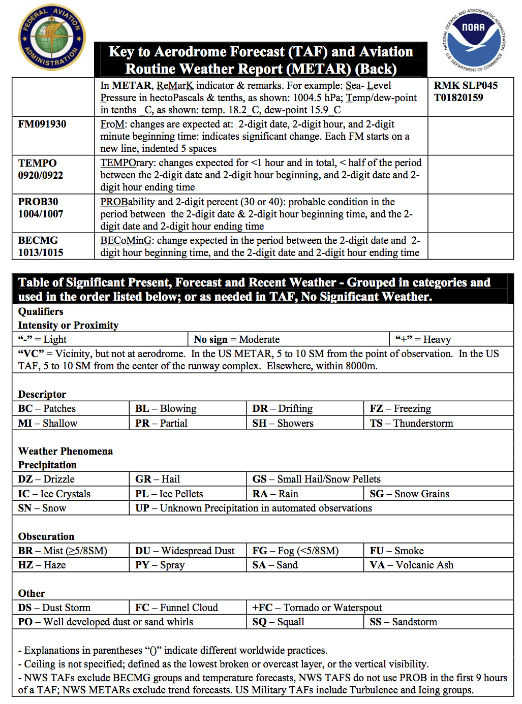
12. Remarks— the remarks sectional ways begins with the letters “RMK.” Comments may or may not appear in this section of the METAR. The information contained in this section may include wind data, variable visibility, beginning and ending times of particular phenomenon, pressure information, and various other information deemed necessary. An example of a remark regarding weather phenomenon that does not fit in any other category would be: OCNL LTGICCG. This translates as occasional lightning in the clouds and from cloud to ground. Automated stations also use the remarks section to indicate the equipment needs maintenance.
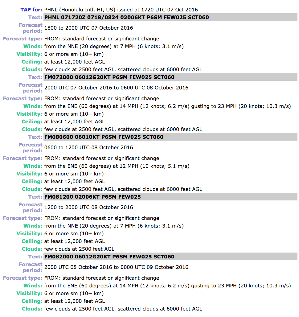
A TAF is a report established for the five statute mile radius around an airport. TAF reports are usually given for larger airports. Each TAF is valid for a 24 or 30-hour time period and is updated four times a day at 0000Z, 0600Z, 1200Z, and 1800Z. The TAF utilizes the same descriptors and abbreviations as used in the METAR report.
Example TAF for: PHNL (Honolulu Intl, HI, US) issued at 1720 UTC 07 Oct 2016
PHNL 071720Z 0718/0824 02006KT P6SM FEW025 SCT060
FM072000 06012G20KT P6SM FEW025 SCT060
FM080600 06010KT P6SM FEW025 SCT060
FM081200 02006KT P6SM FEW025
FM082000 06012G20KT P6SM FEW025 SCT060